
Finding reefs for fishing is one of the most effective ways to catch more fish, especially species like snapper, grouper, amberjack, and redfish that thrive around underwater structure. Reefs create complex habitats in otherwise flat seafloors, attracting baitfish and drawing in predators. The good news is that you do not need years of local knowledge or an expensive deep-sea charter to find them. With modern tools, public data, and a few key strategies, any angler can locate productive reef zones, often within just a few miles of shore.
This guide breaks down exactly how to find reefs for fishing using official databases, digital apps, environmental cues, and proven on-water techniques. Whether you are fishing from a kayak, skiff, or offshore boat, you will learn how to pinpoint reef hotspots, target the right species, and return under the same winning conditions.
Access Official Artificial Reef Maps
Government marine agencies maintain accurate, up-to-date reef location data, and these free sources should be your first stop.
Use State Reef Databases
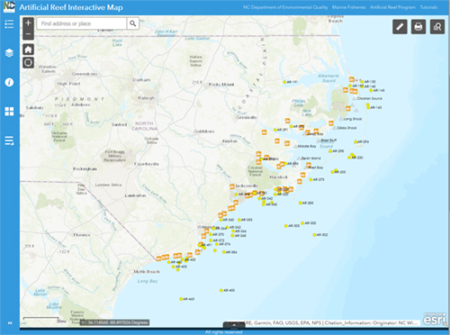
Each coastal state manages designated artificial reef zones with GPS coordinates, materials used, and depth information. These databases are free, legal, and reliable sources for finding reefs.
North Carolina Division of Marine Fisheries offers an Interactive Reef Guide with all 43 ocean and 26 estuarine reefs. You can download KMZ files for GPS and Google Earth, and the database differentiates inshore sites within 5 miles of shore from offshore sites beyond 5 miles. The database updates annually with new reef enhancements.
Alabama Marine Resources Division manages 1,093 square miles of artificial reef zones in the Gulf. The division provides downloadable reef coordinates updated as of September 2024, with zones positioned near every major inlet for easy access.
Escambia County in Florida publishes a Public Artificial Reef List with over 150 GPS points. Files are available in GPX format for GPS devices and KML format for Google Earth. The county encourages anglers to report missing or buried reefs via email.
Pro Tip: Some older reefs may be partially buried. Use sonar or visual cues to confirm structure before dropping lines.
Use Smart Fishing Apps for Reef Discovery
The Salt Strong Smart Fishing Spots app is a game-changer for reef discovery, aggregating state reef data and enhancing it with advanced mapping layers.
Find Reefs with Satellite and Sonar Tools
This digital platform offers several key features for finding reefs. The 4K satellite imagery shows surface water color changes over reefs. The shaded relief layer highlights elevated seafloor areas, with red indicating high points. The 1-foot contour lines reveal subtle ledges, drop-offs, and humps. Color-coded icons distinguish reef types, with red marking artificial reefs, gray showing shipwrecks, and blue indicating barges and tanks.
Click any reef on the app to see GPS coordinates, depth, height off bottom, materials such as concrete or steel, and total volume and size.
Real-World Win: An angler caught a 42-inch redfish on a structure flagged by the app’s predictive Smart Spots layer.
Additional App Features
Beyond reef data, the platform offers Smart Spots with AI-driven predictive zones based on weather, tides, currents, wind, and seasonality. You also get oyster beds and seagrass mapping for inshore species, marine charts with high-detail bathymetry, 3D sonar views for underwater terrain analysis, and weather layers including wind speed, wave height, and storm tracking.
Import Reef Data to Your GPS
Getting reef coordinates onto your onboard navigation system ensures precise targeting when you arrive at the fishing spot.
Use Compatible File Formats
GPX format works with Garmin, Lowrance, Simrad, and Raymarine devices. KML format is ideal for Google Earth and chartplotters. Both formats allow you to transfer waypoints directly from state databases or fishing apps.
Transfer Steps
First, download the reef file from your state agency or Smart Fishing Spots. Second, save the file to a USB drive or SD card. Third, insert the storage device into your GPS or chartplotter. Fourth, import the waypoints under the User Data or Waypoints menu. Some newer systems allow wireless sync via Wi-Fi or Bluetooth, so check your device manual for specific instructions.
Locate Natural Reefs Without Local Knowledge

No reef map? No problem. You can find natural structure using technology and observation.
Use Shaded Relief and Contours
In apps like Smart Fishing Spots, turn on shaded relief to spot red or high areas indicating live bottom. Enable 1-foot contour lines to detect small ledges and breaks. Look for tight clusters of contours, as these indicate structure complexity where fish congregate.
Satellite Overlay in Clear Water
In the Florida Keys or shallow coastal zones, darker patches on satellite view often mark submerged reefs. This technique works best in low turbidity, clear conditions.
On-Water Visual Clues
Once near a potential reef, watch for darker water behind the boat. Notice color shifts from greenish grass flats to brown or gray patches. Use wind-driven current to drift over structure and feel for snags that indicate reef presence.
Read Environmental Cues for Reef Locations
Nature provides free clues when fish are feeding over reefs.
Bird Activity Signals Bait Below
Diving birds such as terns, gulls, and frigatebirds signal baitfish being pushed up from below. This often means tuna, kingfish, or dolphin are feeding below the surface. You can spot bird activity from over a mile away.
Action Step: Head toward bird busts, as they often mark reef edges or floating debris.
Monitor Currents and Tides
Fish use current to feed, so position accordingly. The Gulfstream is a warm, fast-moving current off the southeastern U.S. that holds tuna, marlin, and swordfish. Use the NOAA Tides and Currents Map for real-time flow data. Wind-driven currents create localized eddies around reefs.
The outgoing tide often produces the strongest bites. Fish move to the up-current side of structure to catch drifting food.
Pro Move: Anchor or drift up-current and let chum flow over the reef.
Target Key Seafloor Features

Natural reefs form around distinct underwater landforms that disrupt current, concentrate bait, and create shelter.
Target These Structures
Ledges are sudden depth drops where fish ambush prey. Humps are isolated mounds rising from flat bottom. Canyons are deep trenches with vertical walls. Points are protruding land edges that funnel current. The 100-fathom curve at approximately 600 feet depth is the shelf edge where pelagic species gather.
Fish Around Oil Platforms and Wrecks
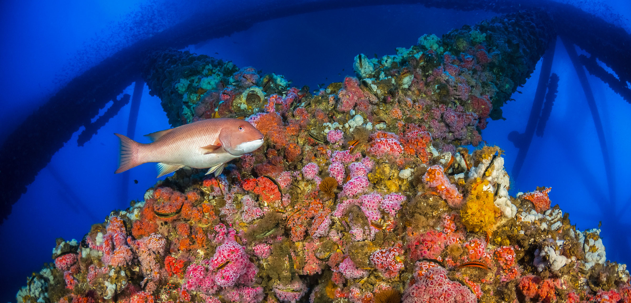
Offshore rigs and sunken ships function as de facto reefs and often hold large predators.
Rigs-to-Reefs Program
Decommissioned oil platforms are converted into artificial reefs through the Rigs-to-Reefs program in the Gulf of Mexico. These structures support dense populations of snapper, grouper, and amberjack.
Caution: Maintain safe distance, as some platforms have restricted zones.
Wreck Fishing Tips
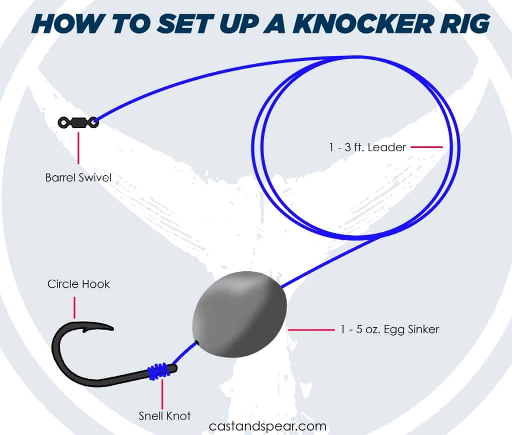
Use heavy tackle because wrecks hold big predators. Avoid snagging by using jig heads or knocker rigs. Fish the edges and shadow zones rather than the center, where lines get stuck.
Know What Fish to Expect on Reefs
Different reefs attract different species. Artificial reefs typically hold red snapper, amberjack, gray triggerfish, and vermilion snapper. Patch reefs in shallow areas produce yellowtail snapper, mutton snapper, grunts, and porgies. Oyster sanctuaries attract redfish, speckled trout, and flounder. Offshore wrecks hold grouper, cobia, king mackerel, and wahoo.
Use Effective Reef Fishing Techniques
Match your gear and method to the structure and target species.
Chumming Strategy
Position your boat up-current of the reef. Deploy live or dead pilchards in a chum bag. Let the scent trail drift naturally over structure. Use 12 or more baits to establish a feeding zone.
Recommended Gear Setup
Use a 7-foot medium-light spinning rod paired with a 2500-size spinning reel. Braid line in 30-pound test provides high strength. A 15-foot leader of 25-pound fluorocarbon resists abrasion from grouper teeth and structure. A small octopus circle hook, Snell-knotted, provides secure bait hold.
Rig Options
Free-lining allows bait to drift naturally behind the boat. Keep the line taut but not tight to allow natural movement. This technique works well for yellowtail and mutton snapper.
The knocker rig uses a weight, bead, and hook without a knot on the line end. The bait hovers a few feet above the bottom. This rig is perfect for grouper, amberjack, and red snapper.
Fish the Right Environmental Conditions
Timing matters as much as location for consistent reef fishing success.
Most Productive Conditions
Successful reef fishing typically occurs during a waning crescent moon with an outgoing tide. Moderate winds around 10 miles per hour from the east-southeast work well. Water temperatures near 82 degrees Fahrenheit and wind-driven currents enhance fish activity.
Pro Tip: Log every trip is conditions. Return when they match those of your best catches.
Follow Best Practices for Success
Use this step-by-step checklist every trip to maximize your reef fishing success.
Your Reef Fishing Checklist
First, open your fishing app and enable shaded relief plus 1-foot contours to identify high points and breaks. Second, verify potential reefs using satellite overlay and look for dark water patches in clear conditions. Third, import GPX or KML files to your GPS and build a custom reef-hopping route. Fourth, time your trip for outgoing tide, moderate wind, and appropriate moon phase. Fifth, position your boat up-current of the reef and let chum flow over structure. Sixth, use circle hooks with Snell knots and 25-pound fluorocarbon leader for abrasion resistance. Seventh, choose your rig based on target species, free-lining for mid-water snapper and knocker rig for bottom dwellers. Eighth, record tide, wind, temperature, and moon phase to replicate success on future trips.
Frequently Asked Questions About Finding Reefs for Fishing
What is the easiest way to find artificial reefs?
The easiest way is to use official state reef databases, which provide free GPS coordinates. States like North Carolina, Alabama, and Florida maintain interactive reef maps with downloadable files for GPS devices.
Do I need a boat to fish on reefs?
No, you can fish reefs from kayaks, especially nearshore reefs within 2 miles of shore. Many productive artificial reefs are accessible from small skiffs and bay boats.
Can I find natural reefs without local knowledge?
Yes, using apps with shaded relief and 1-foot contour layers, you can identify natural reef structure. Look for tight clusters of contours indicating complexity and red or high areas on shaded relief maps.
What app is best for finding reefs?
The Salt Strong Smart Fishing Spots app offers nearly 6,500 artificial reefs with GPS coordinates, depth, relief, and material data. It includes 4K satellite imagery and predictive Smart Spots.
Are artificial reefs safe to fish around?
Yes, but exercise caution around offshore oil platforms due to restricted zones. Some reef areas contain military practice munitions, so never touch suspected ordnance and report hazards to authorities.
Key Takeaways for Finding Reefs for Fishing
Finding reefs for fishing no longer requires decades of local experience or expensive offshore charters. With publicly available reef maps, advanced fishing apps, and simple observation techniques, anglers of all levels can locate productive reef zones consistently. The key is using digital tools like state databases and the Smart Fishing Spots app to identify structure, then applying environmental knowledge about currents, tides, and seafloor features to pinpoint where fish feed. Remember to position your boat up-current of the reef, use appropriate rigs for your target species, and log your conditions to replicate your success on future trips. Start today, and your next big catch is waiting on a reef just miles offshore.