
You’ve heard the saying: “Fish where the fish are.” But if you’re staring at miles of open water, marsh, or mudflats, that advice doesn’t help. The real secret isn’t luck. It’s knowing how to find inshore fishing spots where predatory fish feed consistently. Whether you’re targeting redfish, speckled trout, or snook, success comes from understanding patterns, not guesswork.
The truth? 90% of the fish are in 10% of the water. That’s the 90-10 rule every top angler lives by. Instead of randomly casting, you eliminate unproductive zones and focus only on high-percentage areas shaped by tides, structure, and species behavior. This guide breaks down exactly how to locate inshore fishing spots using tides, technology, visual cues, and real-time intelligence.
Read Tidal Flow Patterns
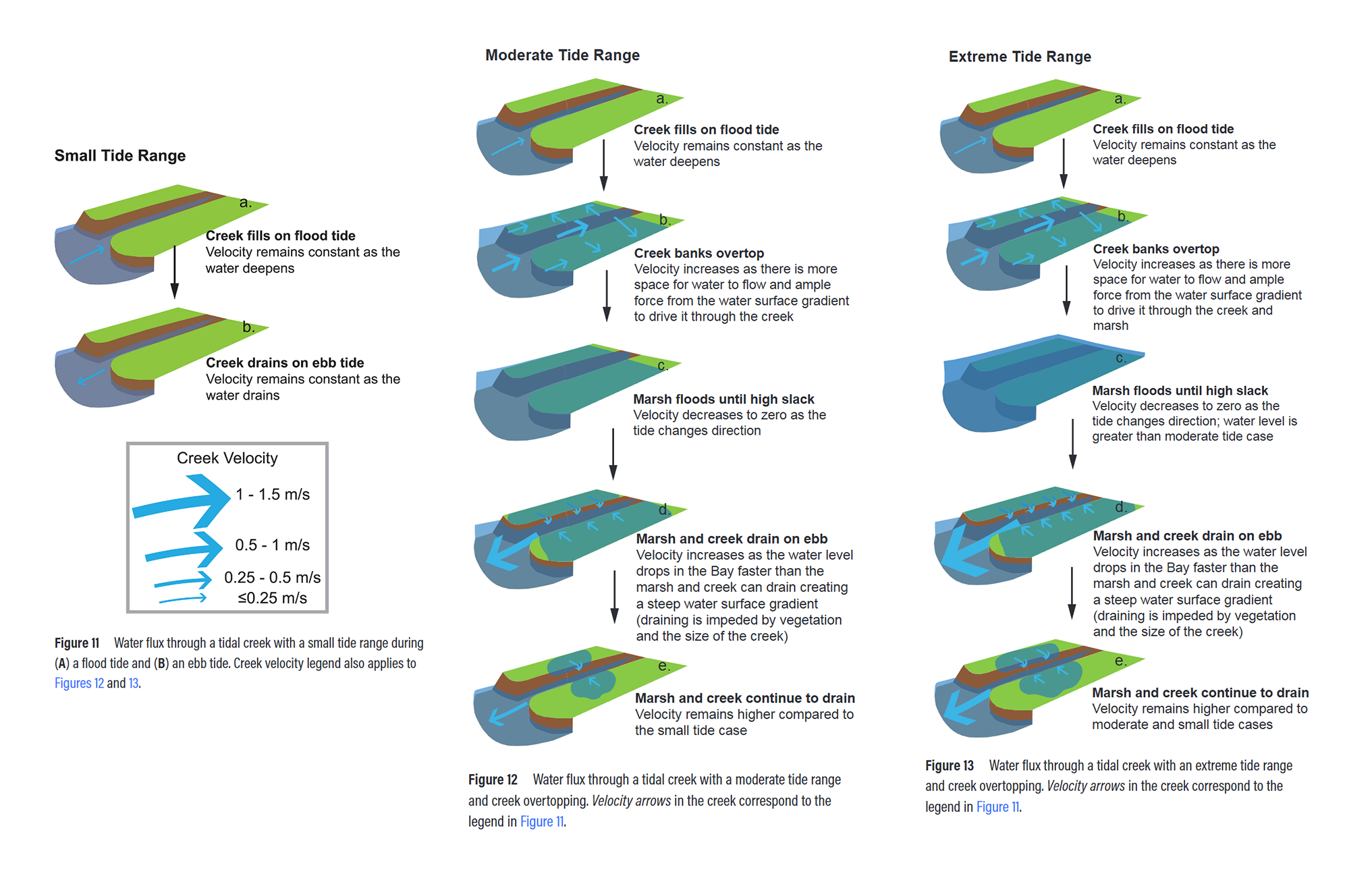
Tides move water, and where water flows, bait and predators follow. Ignoring tide timing is the number one reason anglers fail. The strongest feeding activity happens during mid-incoming or mid-outgoing tides, not slack water.
Target Incoming Tide Zones
As water rises, shallow flats, marshes, and grass beds flood. Baitfish and crabs move in to feed, and redfish follow. Focus on these areas during flood tide.
• Grass flat edges that go from 1 foot to 3 feet deep
• Mangrove shorelines where crabs drop into the water
• Tidal creeks filling with moving water
Pro tip: Arrive 1 to 2 hours before peak high tide to catch redfish moving onto the flat.
Exploit Outgoing Tide Choke Points
When the tide falls, water funnels into channels, dragging bait with it. Predators like speckled trout and snook stack up at natural bottlenecks.
Look for these productive zones.
• Narrow creek mouths
• Drop-offs near flats
• Oyster bars bordering deep holes
Fish the downstream side of structure where current slows. This is where fish ambush prey.
Avoid Slack Tide Dead Zones
When the tide stops, so does the action. Fish scatter and feeding drops sharply. Use this time to move to your next spot, re-rig lures, or check electronics. Plan trips around strongest water movement, not convenience.
Use Wind to Your Advantage
Wind isn’t just about casting difficulty. It affects water flow and fish behavior in predictable ways.
Onshore Winds Boost Feeding
A steady onshore breeze pushes surface water toward shore, enhancing incoming tide flow. This flushes bait into shallow cover, increases oxygen levels, and triggers topwater bites along wind-blown shorelines. Best conditions involve topwater lures at dawn on grassy or mangrove edges.
Offshore Winds Slow Activity
Offshore winds suppress water exchange, especially in enclosed bays. This can reduce bait movement, make fish lethargic, and clear water too much, making fish spooky. Workaround: Focus on deep structure or shaded docks where fish retreat.
Combine Wind Plus Tide for Prime Conditions
Example: Incoming tide plus east wind equals ideal conditions for east-facing flats. Water piles up, current increases, and fish feed aggressively. Use apps like SmartFishingTides.com or NOAA Tides to overlay wind and tide data before you launch.
Match Species to Habitat and Tide
Each inshore species has a predictable pattern. Knowing their habits means knowing where to look.
Find Redfish on Shallow Flats
Redfish move like clockwork with the tide.
• Incoming tide: Hunt crabs on flooded grass flats, 1 to 3 feet deep
• Outgoing tide: Retreat to deep holes or oyster bars
• Visual cue: Look for tailing fish. Their backs break the surface as they root in the mud
Target the edges of seagrass beds, especially near deeper channels.
Locate Speckled Trout in Transition Zones
Trout prefer structure near deep water. They hold in 2 to 5 feet of water over grass flats, ambush bait along drop-offs during outgoing tide, and often stay near sand pockets or oyster clusters within grass fields. Larger trout go ultra-shallow, less than 1 foot, at high tide. Look for nervous water or swirls.
Catch Snook at Current Breaks
Snook are ambush predators. They don’t chase. They wait. They hold behind bridge pilings, downstream of docks, and in eddies near rock walls. Always fish the lee side, down-current, of structure. Cast upstream and let your lure drift into the strike zone.
Warning: Snook vanish when water drops below 55 degrees. In winter, focus on deep, warm-water canals or power plant outflows.
Use Mapping Tools to Scout Spots

You don’t need to be on the water to find hotspots. Use digital tools to pre-scout.
Scout with Google Earth
Free and powerful for initial reconnaissance.
• Zoom in on tidal creeks that narrow into pinched outlets. These are natural funnels.
• Look for shallow areas that dry at low tide. These become feeding zones on incoming water.
• Identify man-made structures: docks, seawalls, spoil islands
Pro move: Drop a pin on potential choke points before you go.
Use Navionics or StrikeLines for Precision
Standard charts show depth, but Navionics, C-MAP, and StrikeLines App reveal micro-structure: oyster beds, small rock piles, subtle depth changes, reef edges. Load these maps to your GPS or fish finder. Look for tight contour lines, which indicate steep drop-offs, equals fish magnets. Look for hard bottom on sonar, shown in red, versus soft mud shown in blue or green.
Access FWC Artificial Reef Data
The Florida Fish and Wildlife Conservation Commission provides GPS coordinates for thousands of artificial reefs and sunken wrecks.
• Download data with accuracy ratings, high, medium, or low
• Focus on larger structures. They’re easier to find and hold more fish.
• Avoid isolated, low-accuracy wrecks unless you have side-scan sonar
Confirm Structure with Fish Finders
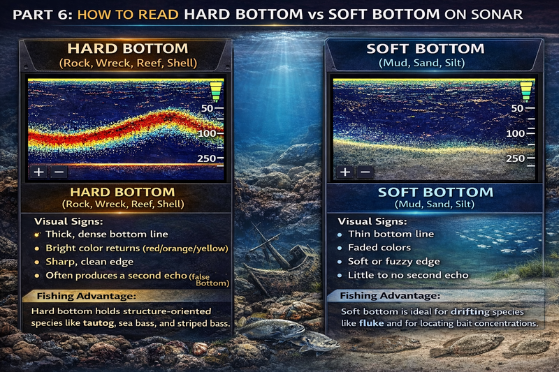
GPS gets you close. Sonar confirms if the spot is worth fishing.
Read Bottom Composition
Different species prefer different bottoms.
• Hard bottom, rock or oyster: Solid red return holds snapper, trout, snook
• Soft mud: Scattered green or blue attracts sheepshead, flounder
• Grass with sand pockets: Mixed return is ideal for redfish
Use zoom function to see small changes in bottom texture.
Spot Fish and Bait on Sonar
Modern fish finders show individual fish arches, schools near bottom, and suspended bait balls. Look for marks near structure during moving tide, bait stacked up in current breaks, and thermoclines in deeper holes, which indicate oxygen-rich layers. If you see nothing after 2 to 3 minutes, move.
Identify Wrecks and Reefs
On sonar, wrecks appear as tall vertical marks. Reefs show as sharp ledges with sand transitions. Fish the edges, not the top. Fewer snags, more strikes.
Watch for Visual Feeding Cues

In clear, calm water, your eyes are your best tool.
Look for Birds Diving
Gulls, terns, or pelicans diving equals baitfish being pushed to the surface. Cast into the edge of the feeding frenzy. Use topwater lures or spoons. Work the perimeter because fish often push bait to the outside.
Note: If birds are diving but you’re not getting bites, switch to smaller lures.
Spot Tailing Redfish
In shallow flats, redfish often tail up while feeding on crabs. Look for V-shaped wakes or exposed tails. Approach quietly using a push pole or trolling motor. Cast a soft plastic or live crab past the fish, then hop it back.
Golden rule: Never cast directly over a tailing fish.
Read Nervous Water
Rippled or pitted surface not caused by wind? That’s nervous water, a sign of fish just below. It’s often seen near drop-offs or grass edges. Cast a topwater popper or twitch bait. Explosive strikes are likely.
Work Structure the Right Way
Structure holds fish, but how you fish it matters.
Fish Docks and Pilings Strategically
Snook and trout love cover.
• Target the down-current side where fish hide
• Cast up-tide and let lure drift naturally
• Use jigs, soft plastics, or live bait
Avoid loud footsteps or shadows. Fish see you.
Target Grass and Oyster Edges
These are transition zones where fish move between deep and shallow.
• Cast parallel to the edge of grass beds
• Use weedless lures to avoid snags
• Try a paddle-tail soft plastic on a weighted hook
Pro tip: Focus on points or bends in the grass line. Current swirls there.
Drift Over Wrecks and Reefs
Don’t anchor directly on structure.
• Drift with the tide to cover more ground
• Use a trolling motor to control speed
• Fish the down-current side. That’s where predators face upstream.
Arrive early. Many wrecks are most active before 9:00 AM.
Get Real-Time Intelligence
Maps and tides are static. Fish aren’t. Conditions change daily.
Track Recent Feeding Trends
Fish respond to cold fronts, rainfall which changes salinity, wind shifts, and water temperature swings. Example: After a cold front, fish go deep and shut down for 1 to 2 days.
Solution: Join fishing forums or subscription services like Salt Strong Insider Club. Experts post weekly updates on where the bite is hot, what lures are working, and which species are active. This is how weekend anglers fish like guides.
Talk to Local Experts
Bait shops are goldmines.
• Ask: What’s biting? Where? With what?
• Employees often know exact spots and preferred baits
• They’ll tell you if water is muddy or clear
Guides also share general tips, even if they won’t give up their secret holes.
Observe Other Anglers
If multiple boats are on a flat or around a bridge, something’s happening. Watch their drift pattern. See what lures they’re using. Note tide stage and time of day. You don’t need to crowd them. Just learn from their success.
Use the 5-Minute Spot Finder Method
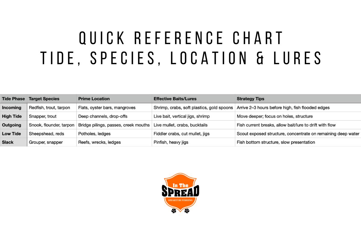
No time to scout? Use this rapid workflow.
- Check tide and wind using apps like SmartFishingTides or NOAA
- Determine tide phase: incoming, outgoing, or slack
- Apply the 90-10 rule. Eliminate open, flat areas
- Pick species-specific zone. Redfish: flooded grass flats. Trout: deep holes near flats. Snook: current breaks at docks
- Use Google Earth or Navionics to find choke points
- Launch and scan with fish finder
- Look for birds, ripples, or tailing fish
This system works anywhere, anytime.
Build Long-Term Success
Great anglers don’t just find spots. They learn patterns.
Keep a Fishing Log
Record date, time, tide stage, wind direction and speed, location, lure used, species caught, water clarity and temperature. Over time, you’ll see trends. Example: Trout bite best on outgoing tide after full moon, or redfish hit topwater at dawn when east wind hits the flat.
Save and Organize Waypoints
On your GPS, name spots by species and structure. Examples: Trout Drop-Off, Snook Bridge. Group by area or tide phase. Revisit under similar conditions.
Join a Fishing Community
Share and learn through local Facebook groups, Reddit saltwaterfishing communities, or club meetings. The more you engage, the faster you improve.
Frequently Asked Questions About Finding Inshore Fishing Spots
What is the best tide for inshore fishing?
The best tide for inshore fishing is during strong incoming or outgoing tides. Mid-incoming and mid-outgoing tides produce the highest feeding activity. Avoid slack tide periods when water movement stops and fish go dormant.
How do I find redfish on a flat?
Find redfish on a flat by targeting grass flat edges during incoming tide. Look for tailing fish, V-shaped wakes, or exposed tails as they feed on crabs. Arrive 1 to 2 hours before peak high tide for the best action.
What apps help find fishing spots?
Helpful apps include SmartFishingTides.com, NOAA Tides, Navionics, and StrikeLines. These provide tide data, wind overlays, and detailed bathymetric maps to identify structure and choke points.
Do I need expensive electronics to find fish?
You don’t need expensive electronics, but a basic fish finder helps confirm structure and locate fish. Start with free tools like Google Earth for scouting, then add sonar as you progress.
How do I read nervous water?
Read nervous water by looking for rippled or pitted surface that doesn’t match wind direction. This indicates fish moving just below the surface. Cast topwater lures into these zones for explosive strikes.
Why should I join fishing communities?
Join fishing communities to access real-time intelligence. Members share weekly reports on what’s biting, where, and with what lure. This helps weekend anglers fish like guides without daily water time.
Key Takeaways for Finding Inshore Fishing Spots

Finding inshore fishing spots isn’t about luck or secret GPS coordinates. It’s about understanding patterns. Tides move bait and predators together. The 90-10 rule means 90% of fish occupy just 10% of the water, so focus on high-percentage zones like structure edges, tidal channels, and current breaks. Match your location to species behavior. Redfish hunt flooded grass flats on incoming tide. Trout hold in deep holes near flats. Snook wait in current breaks behind docks and bridges. Use technology to scout and confirm. Google Earth reveals tidal creeks and choke points. Navionics shows micro-structure. Fish finders confirm bottom composition and fish presence. Watch visual cues. Diving birds, tailing redfish, and nervous water all signal active feeding. Get real-time intelligence from bait shops, guides, and online communities. Conditions change daily, and local knowledge bridges the gap between static maps and today’s bite. Start applying these strategies on your next trip. Focus on moving water, match your spot to the target species, and watch your catch rates climb.